Maps & Statistics
Choose Your Own Adventure.
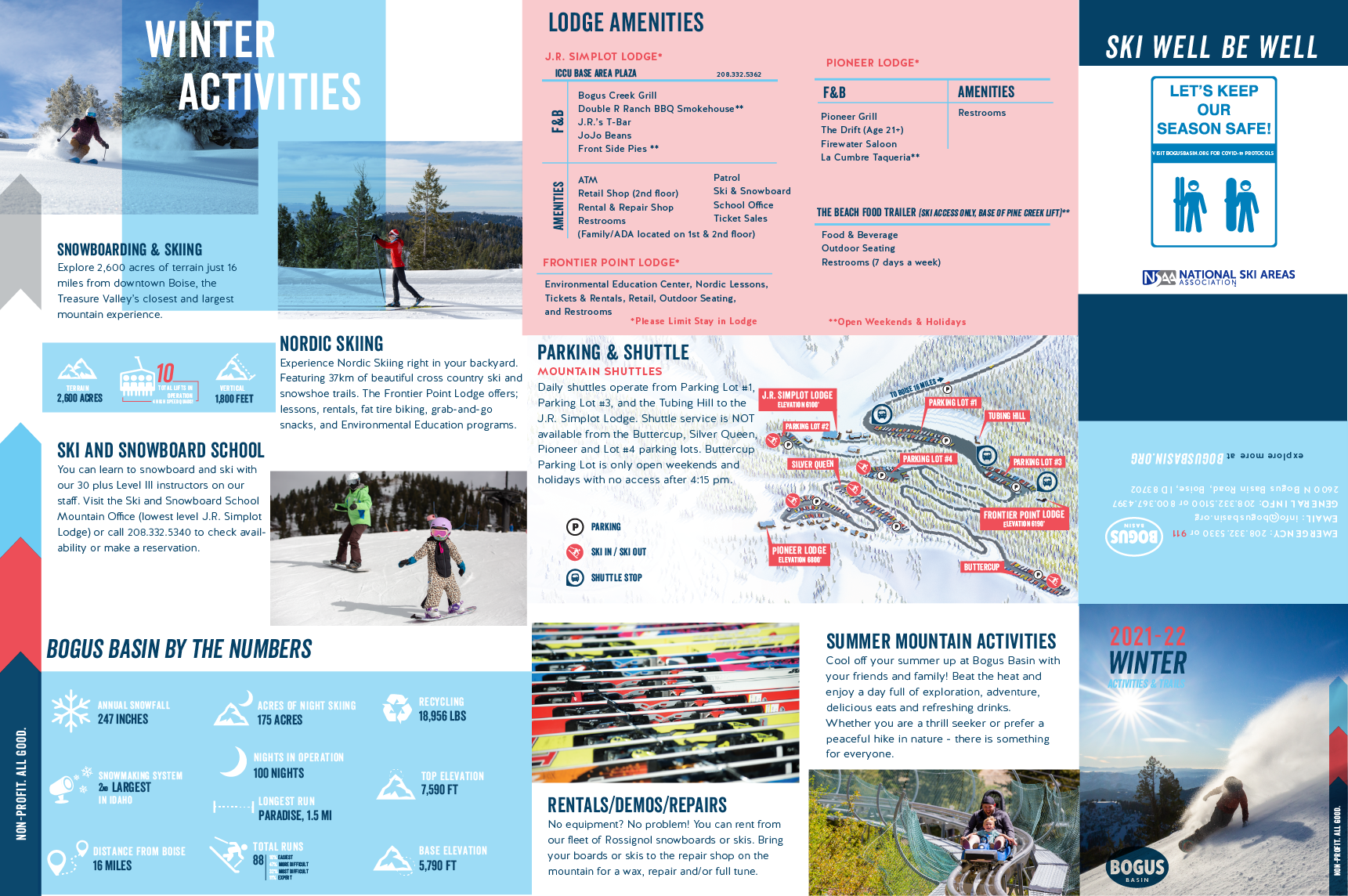
Whether it’s snow-covered or soaked in summer sun, Bogus Basin Mountain Recreation Area is a one-of-a-kind destination. And even though we’re located just 16.5 miles north of Boise, it feels like a whole other world.
![](https://media.bogusbasin.org/uploads/2024/05/28162807/SunCuttingThroughTreesAtBogusBasinSummer2021-PhotoByLukeTokunaga_1365x2048-1066x1600.jpg)
![](https://media.bogusbasin.org/uploads/2024/05/28163459/KarsonCoxRidingDownCowboyCoffeeInTheBasinGravityParkWithin40AcresOfFreedomAtBogusBasin-PhotoByHunterSmith_2048px1365px-1600x1066.jpg)
![](https://media.bogusbasin.org/uploads/2024/05/28163141/BikeTracksOnHeroDirtOnSpaceNuggeTrailAtBogusBasin06-2021_PhotoByLukeTokunaga_2048x1365-1600x1066.jpg)
Summer Maps
Some trails including the Around the Mountain trail are being rerouted this summer, due to the installation of the new Bitterroot and Coach chairlifts. Please use the updated 2024 summer trail maps.
![Summer 2024 Mountain Biking and Hiking Morning Star Map Layout At Bogus Basin Mountain Recreation Area](https://media.bogusbasin.org/uploads/2024/07/03163542/CMYK_Summer24_MorningStar_MapLayout_2048px1029px-600x600.jpg)
Morning Star Zone – The Basin Gravity Park
![Summer 2024 The Basin Gravity Park 40 Acres Of Freedom Bogus Basin Mountain Recreation Area](https://media.bogusbasin.org/uploads/2024/07/03163537/CMYK_Summer24_40AcresOfFreedom_MapLayout_2048px1029px-600x600.jpg)
40 Acres of Freedom Zone – The Basin Gravity Park
![](https://media.bogusbasin.org/uploads/2024/06/13163216/ATMRerouteMapAtBogusBasinMountainRecreationAreaSummer2024TrailClosures_2048px2048px-600x600.jpg)
Around the Mountain Trail Reroutes
![Cross Country Reroute Map At Bogus Basin Mountain Recreation Area _2048px1024px](https://media.bogusbasin.org/uploads/2024/06/13163457/CrossCountryRerouteMapAtBogusBasinMountainRecreationArea_2048px1024px-600x600.jpg)
Cross Country Biking Trail Map
![Hiking Map Trail Reroute At Bogus Basin Mountain Recreation Area Summer 2024](https://media.bogusbasin.org/uploads/2024/06/13163720/HikingMapTrailRerouteAtBOgusBAsinMOuntainRecreationAreaSummer2024-600x600.jpg)
Hiking Trail Map
Parking & Lodge Maps
![Parking map](https://media.bogusbasin.org/uploads/2022/04/20165511/parking-map1-600x600.jpg)
Parking & Lodge/Dining Map
View the parking lots, and where you will grab a meal and a cold beverage.
YOUR MOUNTAIN BY THE NUMBERS
Bogus Basin is the largest non-profit recreation area in the US and Southern Idaho’s largest mountain in terms of rideable terrain. Our lift infrastructure and snowmaking system are top 3 in the state, and we receive about 250″ of snowfall a year.
- Vertical Feet
- 1,800'
- Acres ofTerrain
- 2,600
- Acres of Night Skiing
- 200
- Named Runs
- 90
- Total Lifts
- 10
- High-speed Quads
- 4
Winter Maps
![22/23 Winter Trail Map](https://media.bogusbasin.org/uploads/2022/11/07164843/Winter-_Trail_Map_Web-copy.jpg)
Alpine Trail Map
88 named runs, 4 high-speed quads, 10 lifts, 2,600 acres of terrain, and 360-degree mountain access.
![Nordic Map Card](https://media.bogusbasin.org/uploads/2022/11/09121314/2022_23_NordicMap-02-1.jpg)
Nordic Trail Map
Over 37 km of trails for Nordic skiing, snowshoeing, or fat-tire biking here to help you get a workout during the winter!
![Winter Activities](https://media.bogusbasin.org/uploads/2022/03/17192627/winter-activity-map.png)
Winter Activity Map
Map out your day full of winter fun.